by Dr. Sasithara Sethanandha-Moreno and Aliaga MDRRMO 2022
Betes
Covered with wild grass and trees, Brgy. “Betes” meaning large trees that can hardly be cut down. It began as Sitio (site or place that form parts of Barangay), later became a Barangay. Since Barangay Betes used to be covered with large trees and grass, after the clean-up, people decided to plant crops for food.
Number of Population
2,472
Number of Household
606
Number of Purok
6
Number of School
1
Land Area
5,120,876
Bibiclat
Official and original name of Brgy. Bibiclat was “San Juan Bautista” created and organized in 1899 in honor of the Patron Saint. The community established in 1836, made it 13 years earlier than the town foundation of Aliaga, Nueva Ecija. Bibiclat is a plural form of the word “Bicat” meaning Python in Ilocano dialect. Ilocanos from Lapog, Ilocos Sur were the first settlers, followed by the Pampango from Pampanga. Tagalog is the dialect used by the town people whose faith is Roman Catholic. St.John the Baptist Church situated in Brgy. Bibiclat is known for its Taong Putik Festival, celebrated every June 24.
- 1904 arrival of the Americans: there were private schools in English, Ilocano, and Tagalog.
- 1944 more than 20 young men from the barrio fought at the WWII. One evidence of the barrio’s heroism occurred in November, 1944 when 13 Japanese soldiers led by Capt. Sato were killed by civilians and the USAFE Guerillas under of the able command of the late Carlos Nucom of Talavera.
- 1966 Barangay High School was opened led by Lay Leaders, produced the first batch of graduates in 1969. It is the first Barangay High School in the division of Nueva Ecija to graduate students.
- 1970 (August 25) the Barrio Elementary School became Central School as a result of the division of Aliaga district, the East and the West.
Bibiclat is the biggest barangay in Aliaga with rice fields and vegetable fields, and its musical bands.
Number of Population
8,355
Number of Household
2,048
Number of Purok
7
Number of School
3
Land Area
9,470,745
List of Parish Priests (1978 – 2024)
Diocesan Shrine of St. John the Baptist, Brgy. Bibiclat, Aliaga, Nueva Ecija
Diocese of Cabanatuan
| NAME | YEAR |
|---|---|
| Rev. Fr. Remigio G. Malgapo | July 1978-1984 |
| Rev. Fr. Jose Y. Fajardo | 1984-1985 |
| Rev. Fr. Ireneo De Guzman | 1985-1986 |
| Rev. Fr. Antonio Mangahas | 1986-1989 |
| Rev. Fr. Victor N. Cruz | 1989-1993 |
| Rev. Fr. Cesar M. Bactol | 1993-1995 |
| Rev. Fr. Enrico L. Garcia | 1995-2001 |
| Rev. Fr. William S. Villaviza | 2001-2008 |
| Rev. Fr. Carlos A. Padilla | 2008-2014 |
| Rev. Fr. Elmer S. Villamayor | 2014-2021 |
| Rev. Fr. Perfecto B. Alto, Jr. | 2021-2024 (present) |
References for List of Priests:
Diocesan Shrine of St. John the Baptist (2023). Brgy. Bibiclat, Aliaga, Nueva Ecija
Villamayor, Elmer S. (2021). Mga Tagpo sa Ilang: Karanasan ng Pamayanan ni San Juan Bautista sa Bibiclat. Bibiclat, Aliaga.
Bucot
Arrival of the Spaniards, Brgy. Bucot meaning crooked or twisted; was a flat plain which later converted to a farm land. Original name was Brgy. San Isidro named after its Patron Saint. However, there was a crooked or twisted river once ran across the barrio. One day a stranger passed by and asked the resident who was about 80 years old; what was the name of the river? He replied that the river name is “Sapang Bucot”, since then, it was called Brgy. Bucot.
Number of Population
5,355
Number of Household
1,313
Number of Purok
–
Number of School
1
Land Area
2,548,785
La Purisima
It is one of the oldest Brgy. in the Municipality. During American occupation it was called “tabing ilog” situated in the North Bank of the Talavera River sliced through the boundary of Quezon and Aliaga.
- 1837 big logs carried by flood from Caraballo mountains clogged the Talavera River, causing the portion of the river that ran between Brgy. Pantoc and Brgy. La Purisima to flood the town of Aliaga during rainy season. The closure of the Talavera River led to arrival of immigrants from Ilocos Region.
- 1913 Barrio Tabing Ilog became a barangay during the time of Mayor Gregorio Pascua.
- 1914 after the WWII broke, the residents of tabing ilog moved to Brgy. Poblacion and settled at the “River Side”.
- 1922 (June 12) opening of Elementary School in English. The first teacher was Mr. Arsenio Dawang (from barangay Sto. Tomas) but closed after school year 1922-1923. However, the Elementary School re-opened after the WWII.
- 1936 Brgy. Tabing Ilog was now called Brgy. La Purisima in honor of its Patroness, La Purisima Concepcion.
Number of Population
2,300
Number of Household
511
Number of Purok
4
Number of School
1
Land Area
3,330,984
Macabucod
This brgy. was a forest land that used to be part of Brgy. Sto. Tomas; there were no settlers nor inhabitants. After several years, sudden inhabitants from groups of people called this place “Bagong Silang”. Trees and grass were cleared, made way for more housing from new settlers including an Elementary School. The name “Macabucod” came from the word ‘bukod’ (separated) because of its separation from Brgy. Sto. Tomas.
Number of Population
2,901
Number of Household
645
Number of Purok
7
Number of School
1
Land Area
527,940
Magsaysay
Bgry. Magsaysay originally was a sitio or part of Brgy. Santiago. The leaders of this sitio were Agripino Alfaro and Gregorio Moreno. It was recognized as a Brgy. on February 14, 1957 called “Al Magsaysay” as a mixture of two names; Nueva Ecija Governor Amado Q. Aleta and President Ramon Magsaysay. After the death of President Magsaysay on March 17, 1957; the Brgy. changed its name from Al Magsaysay to “Brgy. Magsaysay”. San Isidro is their Patron Saint.
Number of Population
1,190
Number of Household
265
Number of Purok
–
Number of School
1
Land Area
4,720,190
Pantoc
- 1920 there were only 30 households with population of 50. The first Barrio Lieutenant was Mr. Gavino Tumpalan.
- 1939 opening of Elementary School by its land donor Mr. Gaudencio Molina, the Barrio was named “San Gaudencio Molina”
- In later years the barrio is known as Brgy. Pantoc, believed to be the description of the barrio’s hilly land “bundok bundok” (Santos, Lourdes V. 2023) later known as “Brgy. Pantoc”
- Governor Dr. Leopoldo Diaz commissioned a Pantoc Dam Project to prevent Aliaga from flood.
- September 20, 1979 the school had its electric light through the joint efforts of Mr. Nacario Gonzales, in-charge of the school and barrio council, during the time of Mayor Quirino Dela Cruz.
- Predominantly Catholics and Iglesia ni Kristo, its inhabitants are engaged in farming.
Number of Population
2,786
Number of Household
620
Number of Purok
7
Number of School
1
Land Area
2,599,572
Poblacion Centro / Poblacion East 1 / Poblacion East 2 / Poblacion West 3 / Poblacion West 4
1914 after the WWII, the residents of Brgy. La Purisima moved to Brgy. Poblacion and settled at the “River Side”.
Other residents from Brgy. San Emiliano which was a district town proper or Poblacion, called “Cabasta”; separated from Brgy. San Emiliano and form the new town proper.
In Early 1980’s Población East I, East II, West III and West IV was originally part of the Town Proper of Aliaga, the East part known as Hulo or Tulay na bato which the National high School is located and in the west part known as Luwasan, During the Term of Mayor Nelia Valencia he made a significant astride to create a barangay along the quadrant vicinity of the town proper, she stablish to make a barangay in East Part as Población East I and Población East II and two in west Part as Población west 3 and Población west 4.
As of year 2023:
- Poblacion Centro is where the Municipal Town Hall, Government Offices, Police Station, Nuestra Senora De Las Saleras Church, Elementary Schools, Fire Station, and other major establishments.
- Poblacion East 1 became residential areas and farmland.
- Poblacion East 2 consist of farmland, the Aliaga National High School, gasoline stations, and more residential area.
- Poblacion West 3 is where the Public Market and commercial areas are.
- Poblacion West 4 holds residential area and schools.
Barangay Centro:
Number of Population
2,536
Number of Household
564
Number of Purok
–
Number of School
2
Land Area
212,698
Barangay East 1:
Number of Population
2,627
Number of Household
584
Number of Purok
–
Number of School
2
Land Area
1,219,285
Barangay East 2:
Number of Population
1,667
Number of Household
371
Number of Purok
–
Number of School
1
Land Area
719,290
Barangay West 3:
Number of Population
1,331
Number of Household
296
Number of Purok
–
Number of School
0
Land Area
70,738
Barangay West 4:
Number of Population
768
Number of Household
170
Number of Purok
–
Number of School
1
Land Area
170,738
San Carlos
During Spanish occupation, Brgy. San Carlos was a forest land with wild animals with no inhabitants. The first settlers were native of Ilocos region who built their houses by the edge of the forest and later increased their rice farm land and vegetable farms. More settlers increased and form a community of their own. Their Patron Saint from the native town of the settlers in Ilocos was San Carlos Barromeo, therefore, the Bgry. is called “Bgry. San Carlos” celebrating their feast day every November 4. Brgy. San Carlos has a boundary at Brgy. Dolores, Sto. Domingo Town.
Number of Population
3,608
Number of Household
801
Number of Purok
7
Number of School
2
Land Area
3,350,833
San Emiliano
Originally a district town proper or Poblacion, called “Cabasta” because of its location along the creek. During the Japanese occupations, the inhabitants of the district evacuated to the placed now occupied by the Municipal cemetery in order to escape the harassment inflicted by the Japanese soldiers. During the Liberation, they returned to the respective homes.
- 1954 Cabasta became a Barrio during the time of Lieutenant Proceso Tolentino, with the support from Mayor Zacarias B. Viernes.
- The barrio Cabasta is part of the land owned by Don Emiliano Soriano (land owner and former town Mayor), the name was changed to “Brgy. San Emiliano”.
Number of Population
1,676
Number of Household
373
Number of Purok
7
Number of School
1
Land Area
3,368,934
San Eustacio
Known by the name “Pulong Mayaman”, this piece of land owned by the Kapitan also former town Mayor Anastacio Dimaliwat. After his death, his daughter inherited the land. However, with the Presidential Decree No.27 the Farmers Emancipation Act, this piece of land was distributed to the tenants. In recognition of the Kapitan’s kindness and generosity, the tenants changed the name to “Brgy. San Eustacio”.
Number of Population
2,597
Number of Household
578
Number of Purok
–
Number of School
1
Land Area
1,950,237
San Felipe Bata
Brgy. San Felipe Bata was created by Congressional Act of the defunct Congress of the Philippines in 1970. A part of the old San Felipe, it held the national road that links to Cabanatuan City and Tarlac City.
A progressive barangay has a few landmarks such as health center donated by Provincial Board under Governor Eduardo Joson, a complete elementary school, and a catholic chapel.
Number of Population
2,133
Number of Household
474
Number of Purok
–
Number of School
1
Land Area
1,758,380
San Felipe Matanda
In Spanish time, this Brgy. was a dense forest. Kapitan (Teniente del Barrio) and former Mayor Felipe Medina (1874-1875) was their recognized leader. He had the forest cleaned to form a barrio, therefore, the Brgy. was named after him “Brgy. San Felipe” with San Felipe Neri as their Patron Saint. With the separation of San Felipe Bata (East side) and San Felipe Matanda (West side).
San Felipe Matanda was the only hacienda during the American occupation owned by Dona Sisang De Leon and after on the barrio of small hunts, dirt trails, deep wells and gas lamps, it has transformed into a highly progressive community with agricultural and residential area.
Number of Population
3,056
Number of Household
679
Number of Purok
7
Number of School
1
Land Area
1,869,840
San Juan
Pre-Spanish era, Brgy. San Juan was called “Pintong Gubat” due to its forest land with wild animals. Later the barrio renamed to Brgy. San Juan in honor of former Mayor Juan Cajucom and its Patron Saint San Juan de Dios.
- 1861 Pintong Gubat became a Barrio.
- 1965 the barrio established Elementary School.
- 1966 road construction during the time of President Diosdado Macapagal under roads-building programs brought about the electric power and electric appliances.
The earliest settlers were mostly Ilocanos who were responsible in clearing the land. Upon order of the Governadorcillo. Roads were built leading to the nearly sitios and barrios for the transportation of their crops. That marked the beginning of San Juan progress. During the dark days of the last global war, San Juan has a Huk don. As was to be expected. The hard fact was the Huks were there only to safeguard the security of the barrio. Under the leadership of Barangay Captain Momerto Legaspi, his councilmen, and with the cooperation of the barangay residents, San Juan with its 500 hectares of the land and 3,000 people will match ahead to prosperity. Add to this the presence of irrigation system and an imposing chapel which houses its patron Saint San Juan de Dios.
Number of Population
5,794
Number of Household
1,287
Number of Purok
7
Number of School
2
Land Area
4,060,850
San Pablo Bata
The newly constructed road in Brgy. San Pablo (later called San Pablo Matanda) leading to Tarlac via Zaragoza, gave birth to a new Barrio in 1921 called “Brgy. San Pablo Bata” separated from Brgy. San Pablo Matanda. The Brgy. later established a school in 1951 and chapel, due to more population in its barangay.
The first school building in San Pablo Bata was erected on a lot owned by Pedro Albino; The first chapel, on the lot of Miguel Albino. When Candido Albino was the barrio Lieutenant, a new school house was built on the lot bought from Feder Santos. Opened in 1951, the first teacher was Mrs. Eufemia Sanqueza.
Number of Population
2,267
Number of Household
504
Number of Purok
5
Number of School
1
Land Area
3,744,346
San Pablo Matanda
Brgy. San Pablo Matanda was named after Pablo Tagatac Albino; one of the four settlers from Sarrat, Illocos Norte who arrived in San Pablo in 1854. The other three settlers were Diego Enriquez, Julian Castillo, and Teodora Banot. San Pablo was one of the first barrio that has national road from Cabanatuan City to Tarlac City.
This gave birth to a new barrio in 1921 called San Pablo Bata. The original barrio was renamed San Pablo Matanda.
Number of Population
1,357
Number of Household
301
Number of Purok
4
Number of School
1
Land Area
3,444,450
Sta. Monica
Brgy. Sta. Monica fondly called “Munique” located in the western tip of Aliaga, was a woodland during the early years of the Spanish regime. It was dense forest teaming with wild animals, such as deer, wild pigs, and ducks. Before Brgy. Sta. Monica was part of Sto. Rosario. At present it housed the Talavera River (Sta. Monica – Lapaz, Tarlac River). There is a hanging bridge connecting Aliaga to Licab Town and Zaragoza Town. On the opposite side of the hanging bridge, the locals called the place “Pugad Lawin”. Situated in Brgy. Sta. Monica is “Gapumaca Communal Irrigation System” a part of canal system in Zaragoza, Nueva Ecija. The project is ongoing in year 2023 and known as Gapumaca Dam.
Number of Population
2,675
Number of Household
594
Number of Purok
6
Number of School
1
Land Area
3,960,704
Santiago
Brgy. Santiago is one of the oldest barrios in Aliaga, named after a Spanish General Santiago de Galicia and St. James its Patron Saint. The feast day is celebrated on July 25 to thank the Patron Saint for the wellness that was given to the barrio’s inhabitants and for the good harvest of rice and plantations. It is believed that there was account of miracles during the smallpox epidemic, that town people were saved from the smallpox. As well as farmers’ Novena prayers dedicated to St. James, praying for rain water to be able to plant rice and vegetables; and the rain would come. The feast day is on July 25.
Number of Population
1,306
Number of Household
291
Number of Purok
6
Number of School
1
Land Area
4,468,320
Sto. Rosario
“Malitlit” was the original name of Brgy. Sto.Rosario because of its forest composed of small trees. Due to dedication to Mother Mary, farmers often prayed the holy rosary before leaving their home, later Brgy. Malitlit was renamed to Brgy. Sto.Rosario.
Sto. Rosario consists of Sitio Katuray and Sitio Poitan. It has a complete elementary school; irrigated rice lands the roads and bridges that connect it to the adjacent barangay to the town proper.
Number of Population
2,916
Number of Household
648
Number of Purok
–
Number of School
1
Land Area
4,350,295
Sto. Tomas
Brgy. Sto. Tomas was called Barrio “Pulong Gubat” due to its forest land. Settlers from Ilocos region arrived in 1875 however, it took them around 30 years to clear the land to be suitable for inhabitants. Its Patron Saint Thomas (Sto. Tomas) was chosen from the settlers’ town origin in Ilocos Norte.
The first Barrio Lieutenant was from the Pascua clan. Then from the Lomboy, and Bumanlag clans.
Number of Population
6,293
Number of Household
1,399
Number of Purok
–
Number of School
2
Land Area
5,686,629
Sunson
Located at the Northeast of Brgy. Bibiclat and almost adjoining Brgy. San Carlos, lies a small strip of land known to many as Sunson. First settlers arrived in 1892 converted the forest land into agricultural land. Their product “Gabing Sunsong” is a variety of yam known by villagers nearby. Later the village was called “Sunson” for short and eventually, Sunson Village became Brgy. Sunson.
Number of Population
978
Number of Household
217
Number of Purok
–
Number of School
1
Land Area
2,164,310
Umangan
In the early years of the Spanish regime, Brgy. Umangan was a dense forest with wild animals such as deer, wild pigs, and ducks which was known for its hunting ground (in tagalog umangan). Once the forest was cleared, the land turned into agricultural land. They built huts made of bamboos and cogon grass. With increase of population in the Brgy., the place is later called Brgy. Umangan.
A story is told about a hunter who chanced to pass by and did not know that it was the same place he used to hunt wild animals a few years back because of the presence of many houses. He told the inhabitants that their village was once a hunting ground or “Umangan” of wild animals. From that time on, it was called Umangan.
Number of Population
4,308
Number of Household
958
Number of Purok
–
Number of School
2
Land Area
4,215,320
Words:
Barrio Lieutenant or Teniente del Barrio = Barangay Kaptain
Gobernadorcillo = Mayor
References:
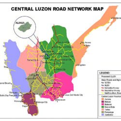
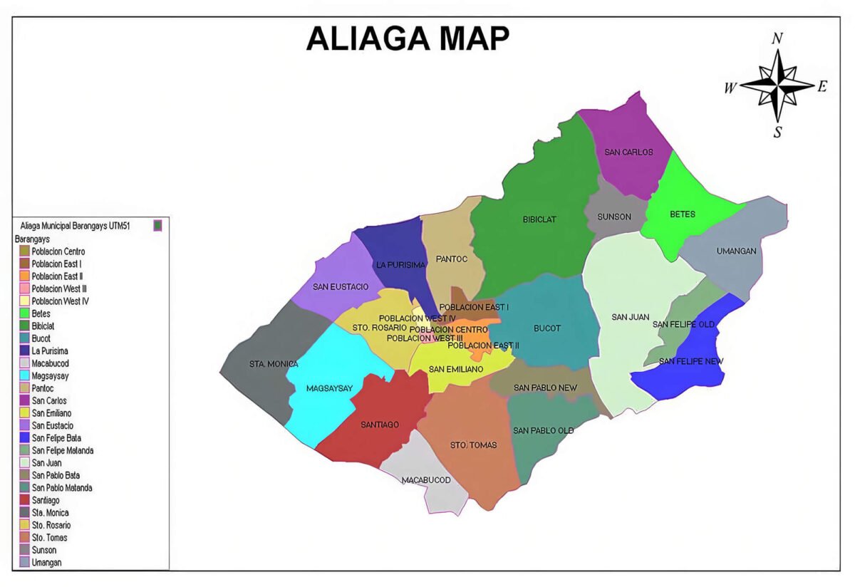
Aliaga LGU (2022). Maps and Profiles. MDRRMO
Barangay History of Aliaga (2010). www.scribd.com
Moreno, Sasithara (2023). Interviewed from 26 Barangays..